S18 Camino Real Pal Pino
Piletas - El Román - SJ Alamo - Teror

It was one of the most important paths to reach Teror, which, besides pilgrims, was also used by passersby and beasts. It was also used by the Virgen del Pino (virgin of the pine ) in her comings and goings to the city. Even in 1677 a small hermitage was built for the rest of the Virgin in San José del Álamo, whose construction was ordered by Juan Coello from Portugal, governor and captain of war.
Nowadays we start this road in the neighborhood of Piletas, exactly in the parking of a well-known supermarket chain. On the same sidewalk, we will go towards to the city, and after about 420 meters we find a roundabout. There we will go to the right, leaving a pharmacy behind, along the street Galileo.
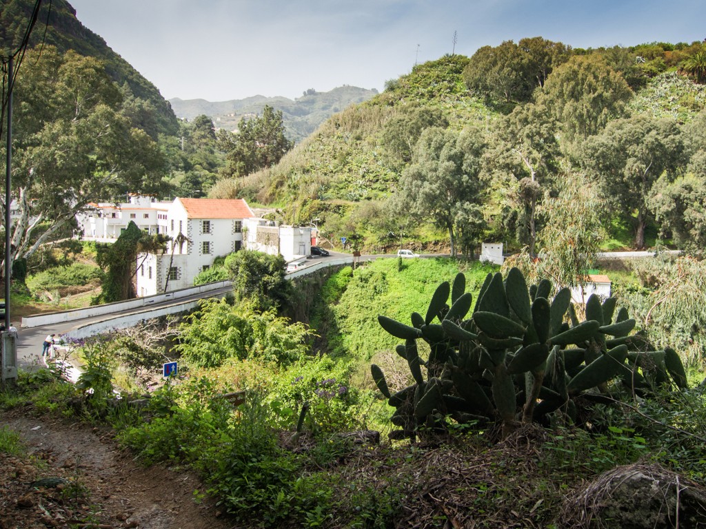
After crossing this street, in the km 0.920 we will find a crossing, where we take the exit to the left, on the street Simón Cananeo. We continue straight until reaching a crossroads. There we will see a park on the right side. We are in km 1.080. Now we will go to the left, on the street Párroco Jorge Casero. At the end of the street (km 1.480), we will enter into a dirt path. If we look to the left, we can see wide farmlands, normally planted with vegetables. In this area we can also contemplate a lot of ponds, which provide water to all the crops throughout the year. Further (km 2.600) we will cross a stones and cement track and continue straight. We will see throughout this area a lot of cactus. They provide Indian cactus fruits ( tunos indios ) to all the people who pass by the place . At the end of the road (km 3.120) we find a cement track. At that point, we take the street Zafiro and keep on with the hike. Exactly at the end of this street begins a climb of stones, which will be our next step. During the ascent we will see several ponds and greenhouse areas, where banana trees are cultivated.
At the end of this first part of the climb, we will reach a place, where, at the right side, we can see the leisure and barbecue area of San José del Alamo. Exactly at this point we take to the left and continue with the climb. During this trip we pass through an area of eucalyptus, leaving them at the right, that will serve to rest under its shade on hot days or take shelter in days of rain. A little higher we reach a cement track and take as a reference the house number 6. We climb that concrete track, then turn to the right and we arrive to the main road (GC-211).Now, we go up on this road about 330 meters, where in a left curve we turn off across the cement entry that we find at the right. Just a few meters after entering, we turn left on the street Camino Real del Pino.
We ascend about 100 meters to reach again the main road (GC-211).
We will move forward in direction to Cruce Lo Blanco, that will be our next crossing point. There are different shops, where you can buy a snack or some food , and there are also a few restaurants. After that, we will continue on the road, leaving the Bar El Cruce on the left side.
Now we will go on in this direction about two kilometers, where we reach a crossing, then we turn to the left on the street La Higuera. We will go up this road without taking any deviation.
At the end of the climb, and after a few meters descent, we will take to the right. This beautiful paved road take us to the Puente del Molino (mill bridge).It is the oldest preserved bridge on the island of Gran Canaria.
El Puente del Molino de Abajo – whose name refers to an old water mill from the 17th century ( beside located ), was built between 1824 and 1828, funded by the Mayordomía del Pino ( Stewardship ) and the collaboration of the neighborhood .
The construction of the bridge supposed an important improvement in the communication between Teror and the capital, and its districts on the other side of the Barranco del Pino ( ravine ). The road to the capital was built a few years later, between 1882 and 1895.
Once crossed the bridge, we turn left on the first exit. That will be our last road until reaching the historic center of Teror.
A few hundred meters after this last turn is the entrance to the Fuente Agria (sour fountain), which we can visit it. It is the fountain that has given greater fame to the municipality along its history for its excellent natural-mineral waters. It is located in the Barranco de Teror, less than a kilometer from the old town, and in the same way from the sea to the top of the island. Along centuries, the water from the Fountain has supplied several generations of Teror´s habitants, and has been one of the main natural resources of the municipality.
There are still lot of people who go to the fountain to fill with water their carafes and bottles.
However, there are also many people who for convenience prefer to buy bottled water from the municipal company, which since 1982 manages directly the marketing of surplus water in benefit of the municipality of Teror. Several times the water from the Fountain has received important distinctions for its properties and in 1928 was declared of Public Utility within the group of medicinal mineral waters. In 1916 the facade of the Fountain was conditioned with stonework, showing it as a monument of nature. If we decide to go to the fountain, we have to return on our steps to continue the climb up until reaching the Plaza ( square ) de Nuestra Señora del Pino, through the street La Escuela.